Washington State Crumbles Under Historic Flooding — Skagit River Set to Shatter Records as Evacuations Rage On
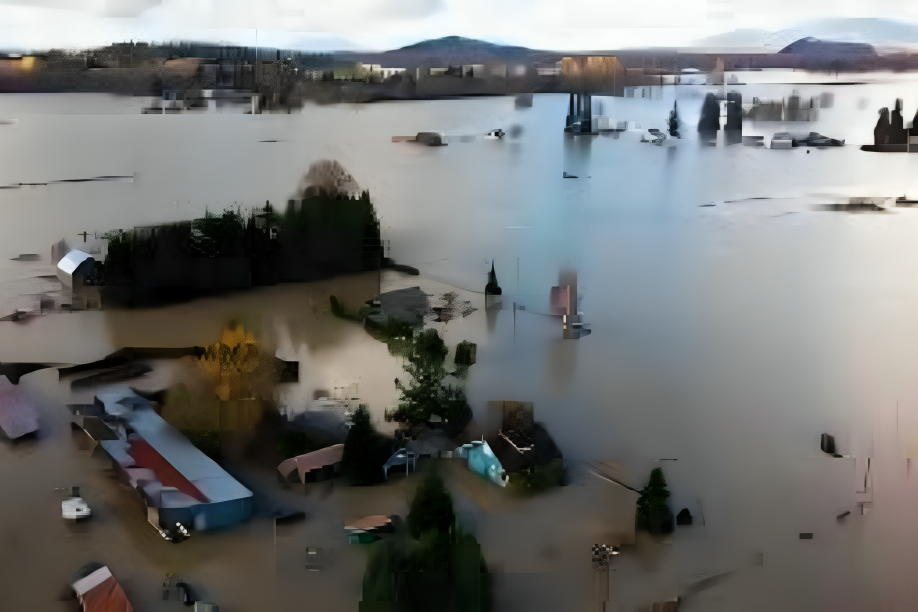
Western Washington flooding has exploded into a full-blown crisis, with rivers across the state threatening to exceed all historical levels and drive untold destruction through Skagit County, Whatcom County, Snohomish County and beyond. What started as a brutal atmospheric river rainstorm has now become the worst flooding emergency Washington has faced in generations — leaving tens of thousands under evacuation orders, roads submerged, and the terrifying roar of the Skagit River flooding echoing through entire communities.
This is not typical winter rain. An atmospheric river carrying record moisture from the Pacific has slammed the Pacific Northwest with relentless downpours for days, driving water levels on major rivers — especially the Skagit River and Snohomish River — to levels that experts warn could dwarf all recent floods.
Evacuations Ordered as Rivers Surge Toward Catastrophic Levels
Authorities sounded the alarm early Thursday, issuing evacuation orders in parts of Skagit County and along key river corridors. Residents in floodplain zones were told to leave immediately as forecasts showed the Skagit River could crest far above its record established in 1990.
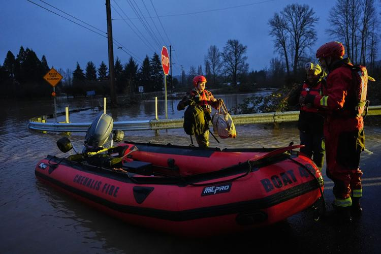
State and local emergency teams declared Level 3 Go Now evacuations for communities near the Skagit and other rivers. These orders mean residents must abandon homes and seek higher ground without delay. In Snohomish County, crews helped rescue people trapped by rising water, while in towns such as Mount Vernon and Concrete, officials warned damage could be historic.
The National Weather Service has already put most of western Washington under flood watches and warnings. A flash flood watch remains in effect for the Skagit River and other vulnerable waterways as water pressure threatens levees and natural barriers.
Skagit River Near Unprecedented Heights
The Skagit River, a lifeblood for communities north of Seattle, now presents one of the most dramatic flood threats. Forecast models indicate the river could crest at nearly 48 feet in Concrete and above 42 feet in Mount Vernon, potentially smashing previous records and overwhelming older flood protections.
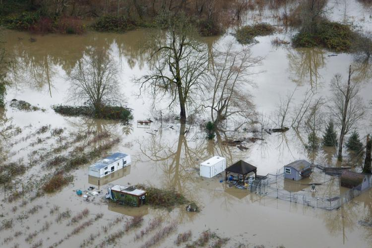
Inside Skagit County, emergency officials and residents scramble to build makeshift barriers, sandbag homes, and move livestock to safer areas. Local volunteer shelters are filling fast as families flee the rising waters.
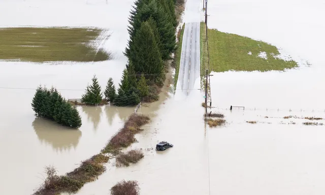
Authorities confirmed that if the river reaches these projected heights, the force could breach key dikes and spill into residential areas, leading to catastrophic flooding across large swaths of the county.
Whatcom County and Beyond Brace for Disaster
North of Skagit, Whatcom County floods have also intensified. The Nooksack River and Samish River, swollen with rainfall, are predicted to hit major flood stages — leaving entire neighborhoods vulnerable.
Whatcom’s South Fork Nooksack is forecast to crest at levels categorized as major flooding, meaning roads, homes, and critical infrastructure face severe flooding within hours.
Statewide Emergency Declared
Governor Bob Ferguson has declared a statewide emergency as the storm’s destructive punch continues. The declaration unlocks additional resources and federal assistance as Washington State flooding worsens. National Guard units have been deployed to assist with search, rescue, and evacuation operations — with hundreds of troops now mobilizing across affected regions.
“This is an unprecedented event, and lives are at stake,” Ferguson said, emphasizing that residents must follow evacuation instructions and use caution around rising waters.
Seattle and Snohomish River Fears
Although Seattle flooding has yet to reach the same catastrophic projections as the more rural counties, heavy rains have pushed several urban waterways close to critical levels. Roads near the Snohomish River flooding have already seen urban flood impacts, with emergency crews responding to stranded motorists.
Snohomish County remains on high alert, with some neighborhoods already evacuated or bracing for potential river breaches. Officials warn that water could pour over levees if rainfall continues at the current pace.
Rivers Across the Region Roar Higher
The flooding crisis isn’t limited to the Skagit or Snohomish. NOAA’s real-time river data shows multiple rivers reaching moderate to major flood stages, including:
- Snoqualmie River
- Puyallup River
- Carbon River
- Grays River
- Skykomish River
These rivers have swelled dangerously, threatening smaller communities and agricultural areas alike.
Additionally, widespread flooding in western Washington has caused major highways such as I-90, US-2, and state routes to shut down due to unsafe conditions and mudslides triggered by saturated hillsides.
Atmospheric River: The Root of the Disaster
Meteorologists point to the intense atmospheric river system that parked itself over the Pacific Northwest as the root cause. These narrow corridors of supercharged moisture delivered week-long downpours that saturated soil, expanded rivers, and melted mountain snow, injecting even more water into Washington’s river systems.
Scientists call this storm one of the strongest atmospheric river events in decades — a dangerous combination of near-record rainfall and swollen watershed conditions.
Evacuations Spread Across Counties
Evacuation orders now stretch from Skagit County south through Snohomish, King, Pierce, and on into Whatcom County. Officials at all levels stress that these orders are not suggestions — many communities face immediate danger from rising water.
Emergency shelters have opened, but volunteers warn that capacity is near its limit as thousands seek refuge. Power outages, road closures, and debris in flood currents continue to complicate rescue operations.
Lives on the Line as Flooding Intensifies
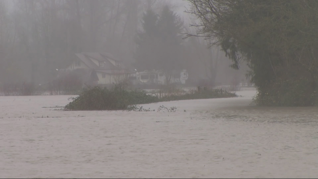
Communities once thought safe now find themselves on a dangerous precipice. In rural Skagit County, families loaded belongings into trucks as they watched the Skagit River flooding rise with terrifying speed. In Whatcom, floodplain residents packed pets and keepsakes before heading to emergency centers. Everywhere, the same question had no reassuring answer: Will our homes still be there tomorrow?
This disaster is still unfolding. With more rain predicted by weather models and rivers expected to surge for days, Washington faces a long, devastating fight against rising waters — and a desperate push to protect lives, homes, and communities.
Stay Alert, Stay Safe — And Capture What Matters with TheFocusCraft
Washington faces one of the most dangerous flooding events in years. Stay connected with TheFocusCraft to get fast, accurate, and reliable updates on Washington flooding, Skagit River surges, Seattle conditions, and every major emergency across the state. We keep you informed when every second counts.
At the same time, protect the moments and properties that matter to you.
TheFocusCraft also offers high-quality photography and real estate photography services — helping homeowners, agents, and families capture important spaces before and after major events.
Whether you’re following breaking news or preparing your property for insurance, documentation, or listing, we deliver clarity, speed, and professional results.
👉 Stay Updated. Stay Prepared. Stay Strong — with TheFocusCraft.